

MGRS vs Lat Long: 7 Essential Survival Secrets Revealed
At-a-Glance: The Navigation Verdict
| Feature | MGRS / USNG | Latitude / Longitude |
| Primary Use | Ground-pounding & Land Nav | Aviation, Marine, & 911 |
| Ease on Paper | High (Metric-based) | Low (Spherical geometry) |
| Global Standard | Military / NATO | Universal / Civilian |
| Stress Factor | Low (Simple numbers) | High (Degrees/Minutes/Seconds) |
| Recommendation | Use for team movements | Use for rescue requests |
If you’re stuck in the woods with a paper map, MGRS is your best friend because it’s built for human brains under pressure. For everything else involving a 911 dispatcher or a smartphone, Lat/Long is the king of the mountain. You need to master both if you plan on actually making it home alive, rather than becoming a cautionary tale for local search and rescue.
The Great Navigation Divide: MGRS vs Lat Long
I’ve spent over 20 years trekking through the kind of backcountry that makes “civilization” feel like a fever dream. In that time, I’ve seen grown men nearly come to blows over the MGRS vs Lat Long debate. It’s the prepper equivalent of Ford vs. Chevy, only with higher stakes—like not walking off a cliff in the dark.
For the uninitiated, navigation isn’t just about knowing where you are; it’s about being able to tell someone else where you are without sounding like a rambling lunatic. I’ve been an outdoorsman and prepper since the days when GPS units were the size of a brick and twice as heavy, and if there’s one thing I’ve learned, it’s that “knowing where you are” is a relative term.
In this guide, I’m going to strip away the jargon and give you the cold, hard truth. We are going to look at MGRS vs Lat Long for land navigation, how to handle MGRS vs Lat Long emergency communication, and the reality of MGRS vs Lat Long GPS accuracy. If you want fluff, go read a travel brochure. If you want to survive, pay attention.
Understanding the Mechanics: What Are We Actually Looking At?
Before we dive into the fight, we need to know what’s in the ring. I’ve found that most people struggle with the MGRS vs Lat Long debate because they don’t actually understand what a coordinate is.
Latitude and Longitude: The Old Guard
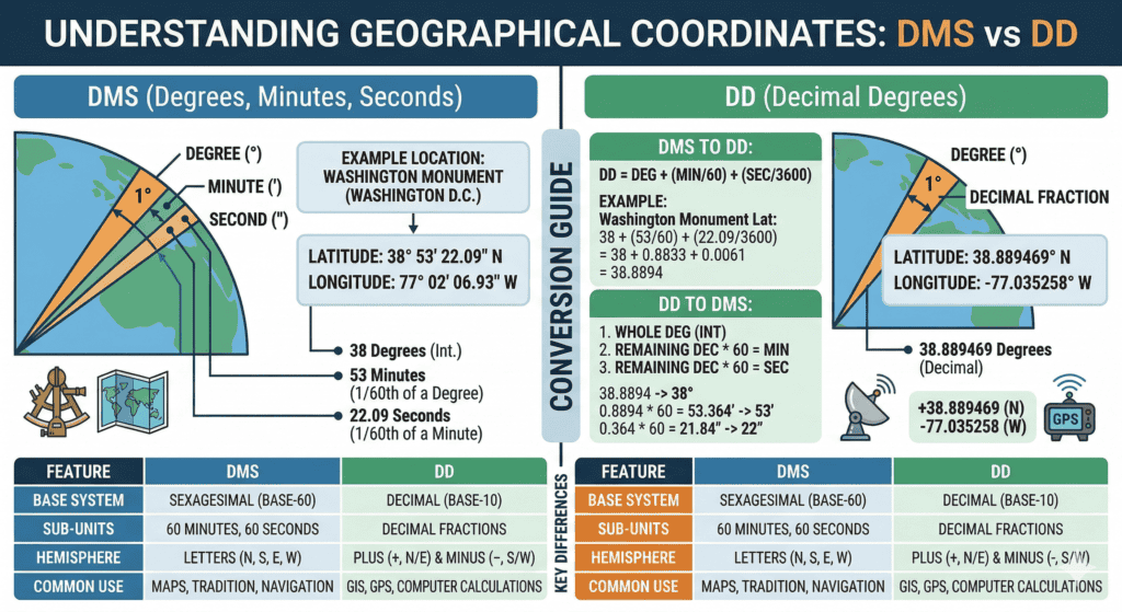
Latitude and Longitude is the OG of navigation. It’s based on a sphere (or an ellipsoid, for you nerds out there). It uses degrees, minutes, and seconds to carve the earth into a grid.
- Latitude: Lines that run horizontal (think “Lat is Flat”).
- Longitude: Lines that run vertical (meridians).
The problem? I’ve tried plotting Decimal Degrees on a 1:24,000 USGS topo map in a rainstorm, and let me tell you, it’s a recipe for a headache. Lat/Long doesn’t translate to linear distance easily. One minute of latitude is roughly a nautical mile, but longitude? That distance changes depending on how close you are to the poles. It’s math I don’t want to do when I’m tired and hungry.
MGRS: The Infantryman’s Gift
The Military Grid Reference System (MGRS) is derived from the Universal Transverse Mercator (UTM) projection. Instead of degrees, it uses a metric grid. It’s basically like looking at a giant sheet of graph paper laid over the world. When I’m moving a group through thick brush, I want to say “Go 400 meters East,” not “Shift 0.003 degrees.”
MGRS vs Lat Long for Land Navigation
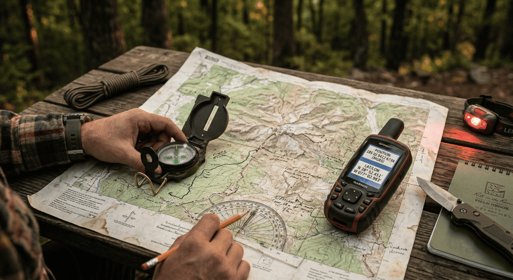
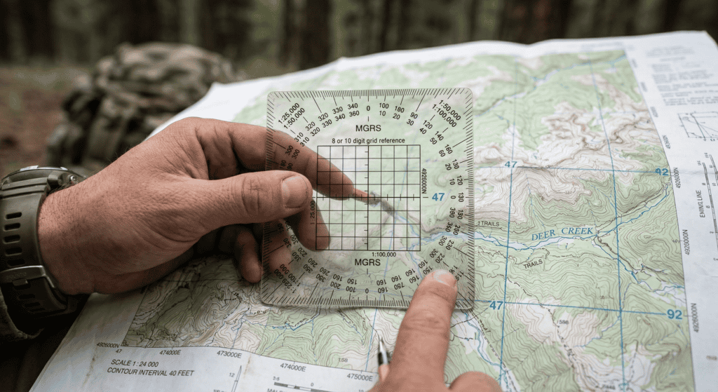
When it comes to MGRS vs Lat Long for land navigation, MGRS wins every single time I’m holding a paper map. Why? Because the math is base-10. If you are using a standard USGS Topo Map, you’ll see grid squares. In the MGRS world, those squares are usually 1,000 meters by 1,000 meters.
I can use a simple plastic protractor to find my location within 10 meters in about five seconds. If I tried that with Lat/Long, I’d be squinting at the margins of the map trying to interpolate seconds and minutes like I’m back in 10th-grade geometry. No thanks.
Why MGRS Rules the Trail:
- Readability: 18S UJ 2345 6789 is easier to shout over a radio than 38° 53′ 23″ N, 77° 00′ 32″ W.
- Scalability: You can drop digits for less precision. A 6-digit grid gets you within 100 meters. An 8-digit grid gets you within 10 meters.
- Distance Calculation: If my grid is 2300 and the objective is at 2500, I know exactly how many meters I have to walk. My brain likes simple.
| Precision | Digits | Accuracy | Use Case |
| Grid Square | 4 digits | 1,000m | Area of Operations |
| Standard | 6 digits | 100m | Land Nav / Waypoints |
| Precise | 8 digits | 10m | Target Identification |
| Pinpoint | 10 digits | 1m | Surveying / Sniping |
MGRS vs Lat Long Emergency Communication
Here is where the MGRS vs Lat Long debate gets spicy. If you break your leg and call 911, and you give that dispatcher an MGRS grid, there is a 90% chance they will have no idea what you are talking about. Most civilian emergency services—including LifeFlight and local Sheriff’s offices—default to Latitude and Longitude (specifically Decimal Degrees).
In my 20+ years of prepping, I’ve had to coordinate with various civilian agencies. They speak the language of Google Maps, not the language of the 75th Ranger Regiment. If you want a helicopter to find you, you better be able to flip that Garmin over to Lat/Long.
This is why I preach “Navigation Literacy.” It’s not about choosing a side; it’s about knowing when to use which tool. In a MGRS vs Lat Long emergency communication scenario, your ability to translate between the two is a life-saving skill. I keep a laminated cheat sheet in my kit that lists both formats for my primary bug-out locations.
The Technical Reality: MGRS vs Lat Long GPS Accuracy
Let’s talk about MGRS vs Lat Long GPS accuracy. I often hear people claim one is more “accurate” than the other. That’s nonsense. Accuracy is determined by your GPS receiver and the satellites it’s talking to, not the coordinate system you choose to display.
Whether you are using a Garmin InReach or a high-end smartphone with Gaia GPS, the device is calculating your position in a mathematical model (usually WGS84). The MGRS vs Lat Long choice is just the “skin” or the language the device uses to show you that data.
However, the human accuracy—the likelihood of you making a mistake—is much higher with Lat/Long. It’s incredibly easy to swap a digit or confuse “Minutes” with “Decimal Minutes.” In the world of MGRS vs Lat Long GPS accuracy, MGRS is more “user-accurate” because it’s harder to screw up the input.
My 20-Year Rule: Use Both or Die Trying
I’ve been doing this long enough to know that tech fails. Batteries die, screens crack, and EMPs… well, let’s just say I don’t trust my life to anything that requires a charging cable.
When I’m training people, I insist they learn to plot MGRS on paper first. Why? Because it builds an intuitive sense of distance and direction. Once you understand that a grid square is a kilometer, you start seeing the world differently. You stop looking at a screen and start looking at the terrain.
The Survivalist’s Training Drills
I don’t just talk about this stuff; I live it. Here are the drills I’ve used for two decades to keep my skills sharp:
- The “Dead Phone” Drill: Go to a trailhead, turn off your GPS, and navigate to three points using only MGRS coordinates and a paper map.
- The “Radio Relay” Drill: Have a partner give you coordinates in Lat/Long. You must convert them to MGRS and plot them on your map within 2 minutes.
- The “Night Blindness” Drill: Try reading your map and plotting a grid using only a red lens flashlight. It’s a lot harder than you think.
The Gear You Actually Need
Don’t be the guy who buys a $600 GPS but doesn’t own a $10 compass. If you’re serious about the MGRS vs Lat Long transition, you need the right kit.
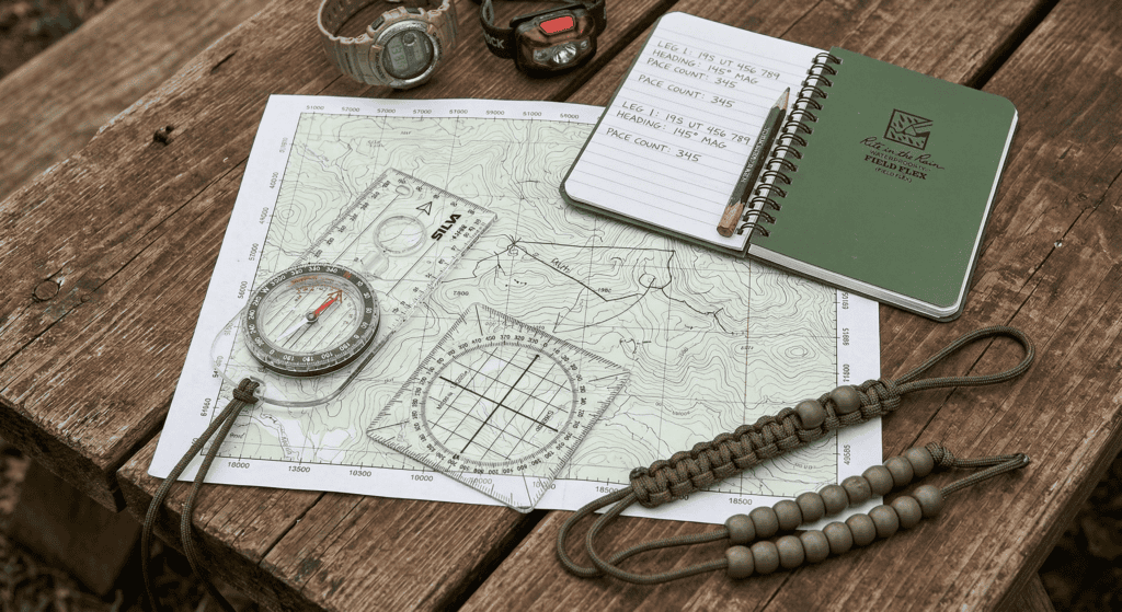
- A Real Compass: I prefer the Suunto MC-2. It has a sighting mirror and an adjustable declination.
- UTM/MGRS Protractor: Essential for plotting. Don’t eyeball it.
- Rite in the Rain Notebook: Because your brain will dump information the second the adrenaline hits. Write your coordinates down.
- Updated Maps: Check CalTopo for the latest layouts.
MGRS vs Lat Long: The Final Showdown
If I’m being sarcastic (which is my default setting), I’d say that if you can’t master both, maybe you should stick to well-marked nature trails with “You Are Here” signs. But since I actually want you to survive the “Big One,” here is the breakdown:
- Learn MGRS if: You are moving on foot, working with a team, or using military-style maps.
- Learn Lat/Long if: You plan on calling for help, using civilian apps, or navigating at sea.
The MGRS vs Lat Long debate isn’t about which is better; it’s about which is appropriate for the moment. I use MGRS for 90% of my movement, but I keep my Lat/Long skills polished because I’m not arrogant enough to think I’ll never need a rescue.
Common Mistakes I’ve Seen
In 20 years, I’ve seen some doozies:
- Mixing Datums: Using WGS84 on your GPS with a map that uses NAD27. That can put you 200 meters off-target. In the woods, that’s the difference between a cabin and a cliff.
- Decimal Confusion: Thinking 40.50 degrees is 40 degrees and 50 minutes. It’s not. It’s 40 degrees and 30 minutes. Math is hard, don’t make it harder.
- The “Nesting” Error: Forgetting the Grid Zone Designator (like 18S). Without that, your grid could refer to a dozen places on earth.
Conclusion: Stop Arguing and Start Navigating
The MGRS vs Lat Long argument is a waste of breath if you can’t actually use either. I’ve seen guys with “MGRS” patches on their gear get lost in a parking lot. Don’t be that guy.
Navigation is a perishable skill. If you don’t use it, you lose it. I make it a point to run a nav course at least once a quarter. It keeps me humble and keeps me alive. Treat your navigation literacy as a high-value asset. It’s an investment in your own “human capital.” If you can’t get to your bug-out location because your GPS died and you can’t read a grid, all that freeze-dried food isn’t going to do you much good.
The bottom line of the MGRS vs Lat Long debate? Use MGRS to get there, and keep Lat/Long ready to tell the world where you arrived.
FAQ: MGRS vs Lat Long for Preppers
Which system is more accurate for a bug-out scenario?
Neither system is inherently more accurate, but in the MGRS vs Lat Long battle, MGRS is superior for bug-outs because it allows for easier distance estimation and faster plotting on paper maps while you’re on the move.
Can I use MGRS on Google Maps?
Not directly. Google Maps defaults to Lat/Long (Decimal Degrees). However, you can find various converters online or use apps like Gaia GPS that allow you to toggle between MGRS vs Lat Long formats instantly.
What is the “Grid Zone Designator” in MGRS?
The GZD is the first part of an MGRS coordinate (e.g., 18S). It tells you which large chunk of the world you are in. If you ignore this in the MGRS vs Lat Long comparison, your coordinates are essentially useless on a global scale.
Do I need a special compass for MGRS?
No, but you do need a special protractor or a map scale. Your compass is for finding your heading; your protractor is for finding your grid. Both are vital when deciding between MGRS vs Lat Long for land navigation.
Is MGRS only for the military?
Technically, yes, but the United States National Grid (USNG) is the civilian version of it and they are virtually identical. For any prepper worth their salt, MGRS is the standard for ground operations.
How do I practice MGRS vs Lat Long at home?
Open up Google Earth, find your house, and try to write down the coordinates in both formats. Then, take a local topo map and try to plot that location using a protractor. It’s the best low-stakes way to master the MGRS vs Lat Long switch.

Would you like me to generate a specific 12-digit MGRS coordinate training sheet for your local area?
Keep Your Skills Sharp
- 👉 DIY Land Navigation Kit That Fits in Your Glovebox
Build a compact, no-excuses navigation kit so you’re never relying on a dead phone again. - 👉 Understanding Magnetic Azimuths: A Navigator’s Guide to Precision
Learn how to actually shoot a bearing without wandering off like a confused raccoon. - 👉 Your Phone’s Dead. Now What? Old-School Navigation for the Modern Moron
When tech fails, this is how you still make it home without starring in a rescue report.