
The Digital Dilemma Every Survivalist Must Solve
Map Reading vs GPS for Preppers: Which Should You Trust When It Matters Most? (2025 Guide)
The Navigation Crisis Nobody Talks About
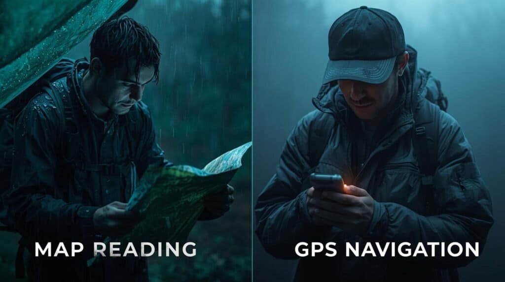
You’re 15 miles off-grid. Your GPS has been flawless for hours, guiding you through unfamiliar terrain with surgical precision. Then everything changes in an instant.
The screen freezes. The battery icon flashes red. Your “smart” navigation device becomes a useless brick of plastic and circuitry.
Panic starts creeping in—until you remember the waterproof topo map folded in your pack. The same map your grandfather insisted you learn to read years ago. Suddenly, that “outdated” skill doesn’t seem so obsolete.
This is the moment every prepper needs to prepare for: when an emergency can happen without warning and the debate of map reading vs GPS for preppers stops being theoretical and becomes life-or-death practical.
Technology delivers precision. Paper provides permanence. The prepared survivalist masters both without apology.
This comprehensive guide settles the map reading vs GPS for preppers debate once and for all—revealing which tool to trust in specific scenarios, how to integrate both systems seamlessly, and why choosing sides is the worst mistake you can make.
Understanding the Tools: Map Reading vs GPS for Preppers
Before we dive into tactics, let’s establish what we’re really comparing when we discuss map reading vs GPS for preppers. This article covers both detailed paper maps and modern GPS systems to help you understand the strengths and weaknesses of each.
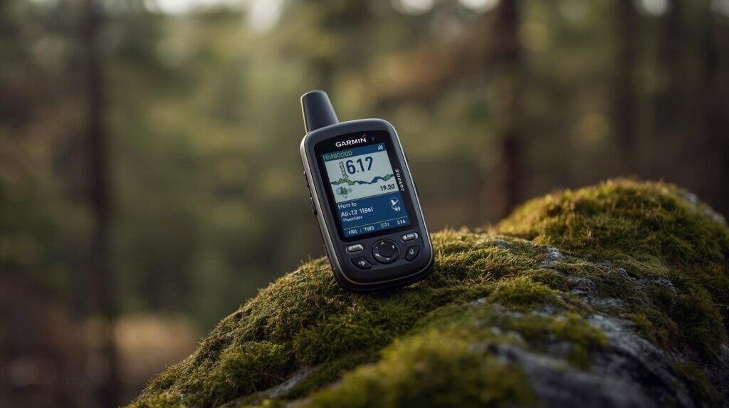
GPS Technology: The Satellite-Powered Navigator
The Global Positioning System uses a constellation of satellites orbiting Earth to triangulate your position with remarkable accuracy. According to GPS.gov, civilian GPS is accurate to within 16 feet under open sky conditions, though many modern receivers achieve 3-10 foot accuracy—an important factor not only for navigation but also for devices like emergency radios that preppers rely on in grid-down events.
GPS Advantages for Preppers:
✅ Pinpoint accuracy (3-10 feet under ideal conditions)
✅ 24/7 operation regardless of weather visibility
✅ Real-time tracking and breadcrumb trails to record and follow your route
✅ Ability to download routes, recalculate paths, and perform navigation tasks even in emergencies
✅ Digital waypoint storage for hundreds of locations
✅ Integration with satellite messaging (inReach, SPOT devices)
✅ Speed and distance calculations automatically
GPS Limitations in Survival Situations:
❌ Battery dependency (15-35 hours typical runtime)
❌ Signal loss under heavy canopy, in canyons, or near cliffs
❌ Fragile electronics vulnerable to water, impacts, extreme cold
❌ Cost factor ($200-$700 for quality units)
❌ EMP vulnerability in theoretical disaster scenarios
❌ Requires satellite visibility to function
The National Park Service notes that GPS devices can lose accuracy or fail completely in slot canyons, dense forests, and other challenging terrain where map reading vs GPS for preppers becomes a critical consideration.
Map Reading: The Time-Tested Skill
Map reading is the analog foundation of land navigation—combining topographic maps, compass work, and terrain association to determine position and plot routes. It’s the “manual transmission” of navigation: more involved, but infinitely reliable.
Map Reading Advantages:
✅ Zero power requirements (works indefinitely)
✅ Immune to electronic failure or signal loss
✅ Big-picture terrain awareness and route planning
✅ EMP-proof and disaster-resistant
✅ Low cost ($7-15 per map)
✅ Teaches genuine navigation skills and spatial awareness
Map Reading Limitations:
❌ Requires training and practice to achieve proficiency
❌ Less precise than GPS (typically 100-300 foot accuracy)
❌ Vulnerable to water damage without proper protection
❌ Time-consuming compared to instant GPS fixes
❌ Physical wear over time (tears, fading)
❌ Declination adjustments needed for magnetic vs. true north
For preppers, having an atlas or road atlas is invaluable. An atlas provides a comprehensive collection of detailed maps for route planning and land navigation, while a road atlas serves as a reliable backup for navigation if digital systems fail.
The U.S. Geological Survey provides excellent free resources on reading topographic maps, which is essential knowledge in the map reading vs GPS for preppers skill set.
Map Reading vs GPS for Preppers: When to Trust Each System
The real answer to map reading vs GPS for preppers isn’t choosing one over the other—it’s knowing which tool performs best in specific situations. When planning bug-out routes, it’s crucial to identify your destinations, such as campsites, water sources, or safe zones, to ensure effective navigation and successful evacuation. Here’s your decision matrix:
Dense Forest & Heavy Canopy: Maps Win
GPS signals struggle under thick tree cover. The U.S. Forest Service documentation on backcountry navigation notes that GPS accuracy can degrade to 100+ feet in dense forest, making terrain association with maps and compass more reliable.
Navigating in back country areas requires strong map and compass skills, as these remote, less-traveled environments often make GPS unreliable.
Why maps excel here:
- Contour lines reveal terrain features GPS can’t “see”
- Compass bearings work regardless of satellite visibility
- You can navigate between clearings using terrain association
Real-world scenario: You’re hiking through old-growth forest in the Pacific Northwest. Your GPS shows your position jumping erratically between two parallel ridges. Your map clearly shows the ridge you’re on based on the creek drainage pattern below. This is map reading vs GPS for preppers in action—and the map wins.
Pro Tip: In heavy canopy, use GPS to grab position fixes in clearings every 30-60 minutes, then navigate between those points using map and compass.
Mountain Terrain & Deep Canyons: Maps Provide Context
Steep terrain creates GPS “shadow zones” where satellite signals can’t reach. Even when GPS works, it shows your position as a dot without revealing the cliffs, ridgelines, and terrain traps that maps display clearly.
The American Alpine Club emphasizes that understanding terrain through map reading remains critical for alpine navigation where GPS fails frequently. Drawing a line between known landmarks on a map helps you orient yourself and determine the best direction to travel in mountainous terrain.
Why maps excel here:
- Contour lines reveal slope steepness and hazards
- Shows alternative routes around impassable terrain
- Helps you plan escape routes before entering danger zones
Storms & Extreme Weather: Paper Doesn’t Care
Heavy precipitation can weaken GPS signals. Lightning forces you to turn off electronics. Snow obscures landmarks. But a properly protected paper map functions flawlessly in any weather.
Weather-proofing your maps:
- Use waterproof paper maps (Trails Illustrated makes excellent ones)
- Store in waterproof map cases (Outdoor Research MapSak)
- Laminate critical maps for permanent protection
This is where map reading vs GPS for preppers becomes a no-contest decision: electronics fail in severe weather, paper endures. With paper maps, you don’t have to worry about battery or signal loss.
Precision Navigation & Waypoint Marking: GPS Takes the Lead
When you need exact coordinates—marking a cache location, finding a specific rally point, or navigating to precise grid coordinates—GPS delivers unmatched accuracy.
GPS excels for:
- Navigating to a specific destination by recording exact locations for future return trips
- Following pre-planned routes with dozens of waypoints
- Coordinating with team members using shared coordinates
- Integrating with satellite messaging for emergency communication
According to REI’s navigation experts, GPS is ideal for precision work when you have sufficient battery backup and appropriate conditions.
Real-world scenario: You’ve cached emergency supplies at a specific location. A GPS waypoint lets you return to within 10 feet of that spot months later. A map gets you to the general area, but GPS pinpoints the exact tree. For this use case in map reading vs GPS for preppers, technology wins decisively.
Extended Off-Grid Operations: Maps Provide Sustainability
The harsh reality of map reading vs GPS for preppers in long-term scenarios: batteries always die eventually.
Battery life comparison:
- Quality GPS unit: 20-35 hours continuous use
- Smartphone GPS mode: 8-12 hours
- Paper map: Unlimited
Even with solar panels and battery banks, electronic navigation creates a dependency. Many digital maps also require an internet connection to function fully, which can be a major limitation in remote areas. Paper maps eliminate both battery and internet connection vulnerabilities entirely.
The Appalachian Trail Conservancy reports that thru-hikers who rely solely on GPS frequently encounter power management problems, while those proficient in map reading navigate confidently without battery anxiety.
Route Planning & Strategic Awareness: Maps Provide the Big Picture
GPS shows you a dot on a screen and the next turn. Maps show you the entire area—water sources, elevation profiles, alternate routes, terrain hazards, and escape options. Understanding your position within the broader country or region is crucial for effective planning and navigation, especially in emergency situations.
Map reading teaches:
- Spatial awareness and terrain pattern recognition
- How to plan efficient routes considering elevation and distance
- Backup route identification before you need it
- Recognizing dangerous terrain before you reach it
This broader perspective makes map reading vs GPS for preppers less about technology versus tradition and more about tactical intelligence versus tactical data.
The Integrated Approach: Combining Both for Maximum Effectiveness
The smartest answer to map reading vs GPS for preppers is refusing to choose. The nice thing about having both systems is the redundancy and reliability they provide, ensuring you have a backup if one fails. Here’s how to build a dual-navigation system that leverages the strengths of both:
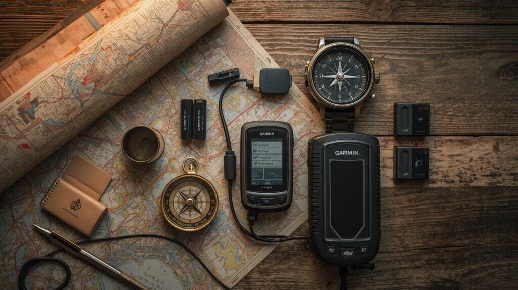
Your Complete Navigation Kit
| Tool | Purpose | Why It Matters | Where to Get It |
|---|---|---|---|
| Garmin GPSMAP 67i | Primary GPS device + satellite SOS | Dual-frequency GPS, global satellite messaging, industry-leading reliability | Check Price on Amazon → |
| Garmin eTrex SE | Backup GPS unit | Runs 100+ hours on 2 AA batteries, simple interface, bulletproof reliability | Check Price on Amazon → |
| Suunto MC-2 Compass | Magnetic navigation + declination adjustment | Best mirror compass for integrating with map work | View on REI → |
| USGS Topographic Maps (Waterproof) | Terrain analysis and backup navigation | Never runs out of power, provides big-picture awareness | Order on USGS Store → or Amazon → |
| National Geographic Trails Illustrated Maps | High-quality regional maps | Waterproof paper, updated regularly, excellent detail | View at NatGeo Maps → |
| Anker 537 Power Bank (20,000mAh) | Extended GPS power | Recharges GPS 3-5 times, solar panel compatible | Buy on Amazon → |
Understanding map reading vs GPS for preppers means recognizing that your GPS is your precision scout, while your map is your strategic commander. One handles tactical details, the other dictates the overall mission.
Field-Proven Integration Tactics
Here’s how to make map reading vs GPS for preppers work synergistically in real-world conditions:
Experts suggest that preppers use both map reading and GPS systems for redundancy, ensuring reliable navigation even if one method fails.
1. Synchronize Before You Move
Before leaving your vehicle or base camp:
- Mark your starting point as a GPS waypoint
- Circle the same location on your paper map
- Record time, coordinates, and magnetic bearing to your first objective
- Take photos of your map with your phone as digital backup
For example, if your GPS shows your starting coordinates as 40.7128° N, 74.0060° W, mark that exact spot on your paper map and label it as “Start.” This ensures both your GPS and map are synchronized before you move.
This creates a baseline anchor point for both systems, making the map reading vs GPS for preppers debate moot—you’re using both from the start.
2. Capture GPS Waypoints, Plot Them on Paper
Modern GPS devices can store hundreds of waypoints, but that data lives in a fragile device. Transfer critical waypoints to your paper map:
- Use GPS to record exact coordinates of water sources, campsites, hazards
- Use satellite view on your GPS device to identify landscape features and structures before plotting them on your map
- Plot those coordinates on your map using grid references
- Now you can navigate to those points even if GPS fails
The Leave No Trace Center recommends this redundancy approach for all backcountry travel.
3. Confirm Terrain Features Every Hour
As you move through terrain:
- Use GPS for real-time position tracking
- Every 30-60 minutes, stop and identify terrain features on your map
- Confirm what you see physically matches what the map shows
- When navigating between waypoints, try to follow a straight line for efficient travel and to simplify confirming your position with both GPS and map.
- Adjust your mental map of the area based on ground truth
This habit builds terrain association skills while maintaining GPS precision—the best of both worlds in map reading vs GPS for preppers.
4. Pre-Mark Critical Waypoints and Bailout Routes
Before entering challenging terrain:
- Use GPS to mark where you entered
- Plan escape routes on your map before you need them
- Set GPS proximity alarms for known hazards
- Identify safe zones (roads, trails, landmarks) in all directions
- Obtain updated maps and information from ranger stations to ensure you have the latest trail and topographical details
According to Mountain Rescue Association statistics, most navigation-related rescues involve people who failed to plan escape routes before entering difficult terrain.
5. Always Carry a Quality Compass
Compasses are essential navigation tools for preppers. If both GPS and map fail (rare but possible), a compass and basic navigation knowledge lets you walk out on a bearing to the nearest road or known landmark.
Minimum compass skills every prepper needs:
- Taking and following bearings
- Understanding magnetic declination
- Triangulation for position fixing
- Using terrain features as handrails
The Boy Scouts of America provides excellent compass training resources that complement the map reading vs GPS for preppers skill set.
Critical Mistakes That Undermine Both Systems
Even experienced outdoorspeople make these errors that compromise the map reading vs GPS for preppers integration:
If your GPS device is not properly updated, it can lead you the wrong way due to outdated maps or errors, so always double-check your route and have a backup navigation method.
❌ Mistake #1: Relying Solely on Smartphone GPS Apps
Why it fails: Phones overheat in summer, freeze in winter, shatter when dropped, and die within 8-12 hours even in GPS-only mode.
The fix: Phones are convenient secondary tools, but never your primary GPS. Invest in a dedicated handheld unit with proper weatherproofing and multi-day battery life.
Outdoor Life’s gear testing consistently shows dedicated GPS units outperforming smartphones in reliability, battery life, and durability.
❌ Mistake #2: Outdated GPS Firmware and Maps
Why it fails: Old satellite almanac data increases GPS acquisition time from seconds to minutes. Outdated maps show roads and trails that no longer exist.
The fix:
- Update GPS firmware quarterly using Garmin Express
- Replace topographic maps every 2-3 years
- Download fresh satellite data before every major trip
❌ Mistake #3: Ignoring Magnetic Declination
Why it fails: Compass bearings are magnetic. Map bearings are true north. The difference (declination) varies by location and changes over time. Ignoring this creates navigation errors of several degrees per mile.
The fix: Check current declination at NOAA’s Magnetic Declination Calculator before your trip. Set declination on your compass or manually adjust bearings.
Understanding declination is fundamental to making map reading vs GPS for preppers work together accurately.
❌ Mistake #4: Zero Practice Before Emergencies
Why it fails: You can’t learn land navigation while lost, scared, and running out of daylight. Skills atrophy without practice. It’s crucial to practice navigation skills before a survival situation occurs, so you’re prepared when it matters most.
The fix:
- Practice map and compass navigation quarterly
- Take GPS-free hikes to maintain manual navigation skills
- Join an orienteering club (Orienteering USA)
- Run scenarios: “If my GPS died right now, could I navigate out?”
The Search and Rescue community reports that most people who get lost possess GPS devices—they just don’t have the backup skills to navigate when technology fails.
Building True Navigation Competence
Navigation skills play a crucial role in emergency preparedness, enabling individuals to effectively find their way and access vital resources during unexpected situations.
Mastering map reading vs GPS for preppers requires moving beyond theoretical knowledge into practical skill development:
The 90-Day Navigation Mastery Plan
Month 1: Foundation Skills
- Week 1-2: Study topographic map basics (contour lines, scale, symbols)
- Week 3-4: Practice compass bearings and triangulation in local parks
- Goal: Navigate a 3-mile loop using only map and compass
Month 2: Integration Practice
- Week 5-6: Combine GPS and map navigation on longer hikes
- Week 7-8: Practice GPS-to-map coordinate transfer
- Goal: Complete a 10-mile route using both systems seamlessly
Month 3: Stress Testing
- Week 9-10: Navigate in challenging conditions (night, weather, thick forest)
- Week 11-12: GPS-off hike—navigate entirely by map and compass
- Goal: Build confidence in self-reliance paper-only navigation
This structured approach transforms map reading vs GPS for preppers from an academic debate into practical mastery. Navigation is a core survival skill, essential for emergency preparedness and overall survival skills development.
Recommended Training Resources
- REI Outdoor School Navigation Classes – Hands-on workshops
- USGS Topographic Map Reading Guide – Free comprehensive tutorial
- Garmin GPS Tutorial Videos – Device-specific training
- “Be Expert with Map and Compass” by Bjorn Kjellstrom – Classic navigation textbook
- National Outdoor Leadership School (NOLS) – Professional-grade wilderness navigation courses
Advanced Considerations for Serious Preppers
Topo maps are essential for advanced navigation, especially in survival situations where GPS or electronic devices may fail.
Taking map reading vs GPS for preppers to the next level requires understanding these advanced concepts:
Multi-GNSS Capability
Modern GPS receivers don’t just use American GPS satellites. They access:
- GPS (USA) – 31 satellites
- GLONASS (Russia) – 24 satellites
- Galileo (Europe) – 30 satellites
- BeiDou (China) – 35+ satellites
According to the European Space Agency, multi-constellation receivers significantly improve accuracy and reliability in challenging terrain where single-system GPS fails.
Devices with multi-GNSS support:
- Garmin GPSMAP 66i/67i series
- Garmin Montana 700i/750i
- Garmin Oregon 700/750t
This capability makes GPS more reliable in the map reading vs GPS for preppers equation, but still doesn’t eliminate the need for paper backup.
EMP and Solar Storm Considerations
For preppers concerned about extreme scenarios, electromagnetic pulses or severe solar storms could theoretically disrupt GPS satellite networks and damage electronic devices.
Reality check from NASA:
- GPS satellites are hardened against solar events
- Temporary disruptions possible, not permanent destruction
- Handheld GPS receivers might survive EMP if powered off
Prepper takeaway: Paper maps remain your ultimate insurance policy, which is why map reading vs GPS for preppers always favors redundancy over reliance on any single system.
Grid-Down Navigation Strategy
In a true long-term grid-down scenario:
- GPS satellites will continue broadcasting (military infrastructure)
- Your handheld devices eventually die without charging capability
- Map and compass skills become your primary navigation method
- Pre-printed maps of your region are irreplaceable
This scenario makes the map reading vs GPS for preppers debate decisively favor traditional skills, though GPS remains valuable while it lasts.
Real-World Lessons from the Field
After years of backcountry navigation in the Ozarks, Appalachians, and Western mountains, here’s what practical experience teaches about map reading vs GPS for preppers:
Navigating in the woods presents unique challenges, as dense forests and remote terrain can make it easy to lose your way without proper skills and preparation.
Story #1: When GPS Failed Completely
Deep in a Pennsylvania canyon, my GPS lost satellite lock entirely. Steep walls blocked signals from every direction. But the topographic map clearly showed the creek drainage I was following would lead to a forest service road in 2.3 miles.
The lesson: GPS provides precision when it works. Maps provide direction when nothing works.
Story #2: When Maps Showed What GPS Couldn’t
My GPS indicated I could cut straight across a valley to save distance. The map’s contour lines revealed that “short cut” involved a 400-foot cliff band that would have been dangerous or impossible to descend.
The lesson: GPS shows position. Maps show terrain reality.
Story #3: When Both Systems Together Saved Time
Planning a 30-mile backpacking route, I used GPS to identify water sources and campsites, then plotted them on my map to visualize terrain between points. This revealed a high-elevation route that avoided most elevation loss and gain.
The lesson: Map reading vs GPS for preppers is a false choice. Combined, they provide capabilities neither offers alone.
Your Action Plan: Implementing Dual Navigation
Stop debating map reading vs GPS for preppers and start building competence in both:
Immediate Actions (This Week)
✅ Order topographic maps of your region from USGS Store or MyTopo
✅ Waterproof your maps with lamination or map cases
✅ Update GPS firmware and download latest satellite data
✅ Test GPS battery life with a full-day field test
✅ Practice basic compass work in a local park
Short-Term Development (Next 30 Days)
✅ Complete a GPS-free navigation exercise using only map and compass
✅ Learn to plot coordinates from GPS to paper map
✅ Mark critical waypoints for your primary bug-out routes
✅ Practice declination adjustment on your compass
✅ Build redundant map storage (originals, laminated copies, digital photos)
Long-Term Mastery (Next 90 Days)
✅ Take a formal navigation course through REI, NOLS, or orienteering club
✅ Complete 10+ hikes using integrated map/GPS navigation
✅ Build a bug-out bag navigation kit with both systems
✅ Teach someone else basic map and compass skills (teaching reinforces mastery)
✅ Run realistic scenarios testing backup plans when primary systems fail
The Final Verdict on Map Reading vs GPS for Preppers
After analyzing capabilities, limitations, and real-world performance, here’s the truth about map reading vs GPS for preppers:
You need both. End of discussion.
GPS provides precision, speed, and digital convenience when it works. Maps provide reliability, permanence, and strategic awareness regardless of conditions.
The prepared survivalist doesn’t choose—they integrate. GPS becomes your tactical tool for pinpoint accuracy and waypoint navigation. Maps become your strategic asset for terrain analysis and backup when electronics fail.
The formula for navigation confidence:
🛰️ GPS = Primary precision tool
🗺️ Maps = Strategic awareness and backup system
🧭 Compass = Universal fallback when everything else fails
🧠 Skills = The only tool that never runs out of batteries
Technology is your edge. Skill is your safety net. Redundancy is your insurance policy.
The prepper who masters map reading vs GPS for preppers isn’t the one who picks a side—it’s the one who refuses to be dependent on any single system.
Because when you’re 20 miles from the nearest road and your GPS dies, your response shouldn’t be panic. It should be reaching for your map with quiet confidence, knowing you have the skills to navigate out safely.
That’s the difference between owning gear and being truly prepared.
Frequently Asked Questions
Can GPS completely replace traditional map reading for preppers?
No. GPS depends on satellites, batteries, and electronics—all of which can fail. According to Emergency Management experts, redundant navigation capabilities are essential for true preparedness. The map reading vs GPS for preppers question should always result in “both, not either.”
What’s the best GPS device for serious preppers?
The Garmin GPSMAP 67i is the current gold standard, offering dual-frequency GPS, multi-GNSS support, and integrated satellite messaging via the Iridium network. For budget-conscious preppers, the Garmin eTrex SE provides excellent reliability at a lower price point.
How often should I replace or update my topographic maps?
Replace maps every 2-3 years or when significant changes occur to roads, trails, or terrain features in your area. Check the map publication date and compare against known conditions. The U.S. Geological Survey regularly updates their topographic maps with the latest data.
Do I really need to learn compass navigation if I have GPS?
Absolutely. Batteries die, GPS units break, and signal loss happens. Compass navigation combined with map reading provides an independent backup system that works in any conditions. The map reading vs GPS for preppers skill set requires competence in both.
What’s the minimum navigation gear for a bug-out bag?
- 1 primary GPS unit (with extra batteries or power bank)
- 2-3 laminated topographic maps of your region
- 1 quality baseplate or mirror compass
- Waterproof map case
- Pencils and waterproof paper for notes
This kit ensures you have redundancy across multiple navigation methods in the map reading vs GPS for preppers spectrum.
Should I invest in paper maps if I can download digital maps?
Yes. Digital maps on phones or GPS devices can be deleted accidentally, become corrupted, or be inaccessible when devices fail. Physical maps are permanent, don’t require power, and work in any condition. This is fundamental to understanding map reading vs GPS for preppers.
How accurate is compass navigation compared to GPS?
GPS provides 3-10 foot accuracy under ideal conditions. Compass navigation typically achieves 100-300 foot accuracy depending on skill level and terrain. For hiking and land navigation, this is more than sufficient. The American Hiking Society notes that terrain association skills matter more than absolute precision in wilderness navigation.
Can an EMP actually destroy GPS satellites?
Probably not. GPS satellites are hardened against electromagnetic interference and operate in protected orbits. However, an EMP could potentially destroy handheld GPS receivers on the ground. This is why paper maps remain essential in the map reading vs GPS for preppers redundancy strategy.
Related Resources
- USGS Topographic Maps: Complete Guide – Official USGS map resource
- GPS.gov: How GPS Works – Government GPS technical documentation
- REI Expert Advice: Navigation Basics – Comprehensive navigation tutorials
- NOAA Magnetic Declination Calculator – Calculate declination for your location
- Leave No Trace: Navigation Best Practices – Responsible backcountry travel
Remember: The best navigation system is the one you know how to use when everything else fails. Master both. Trust neither exclusively. Navigate confidently.
📶 Stay oriented. Stay prepared. Stay found.
Heads-Up, Fellow Preppers:
Some links in this post are sponsored or affiliate links. If you click and buy, I may earn a small commission—enough to restock my peanut butter and maybe add one more can of chili to the stash. I only recommend gear I trust, use, and would hide in a bug-out bag.