
Declination Navigation for Beginners: Stop Turning Your Map into a Useless Paperweight
Why Your Map Skills Might Already Be Failing You
Imagine this: You’ve got your brand-new topo map, a shiny compass dangling from your neck, and that smug “I could’ve been a Navy SEAL if I’d wanted to” confidence. You line up your compass, stride boldly into the woods… and end up two ridgelines over, staring at a cow pasture that was definitely not on your route.
Master declination navigation, and your map goes from paperweight to precision instrument. For more essential survival skills, check out our complete prepper’s guide to wilderness navigation.
Congratulations—you’ve just been sucker-punched by declination navigation. It’s that sneaky little angle between magnetic north (where your compass needle points) and true north (the actual North Pole). Ignore declination navigation principles, and your map skills are about as useful as a waterproof match in a monsoon.
The good news? Once you understand declination navigation and how to apply it correctly, your map stops being a useless piece of paper and becomes your most reliable survival tool.
What Is Declination? The Science Behind the Confusion
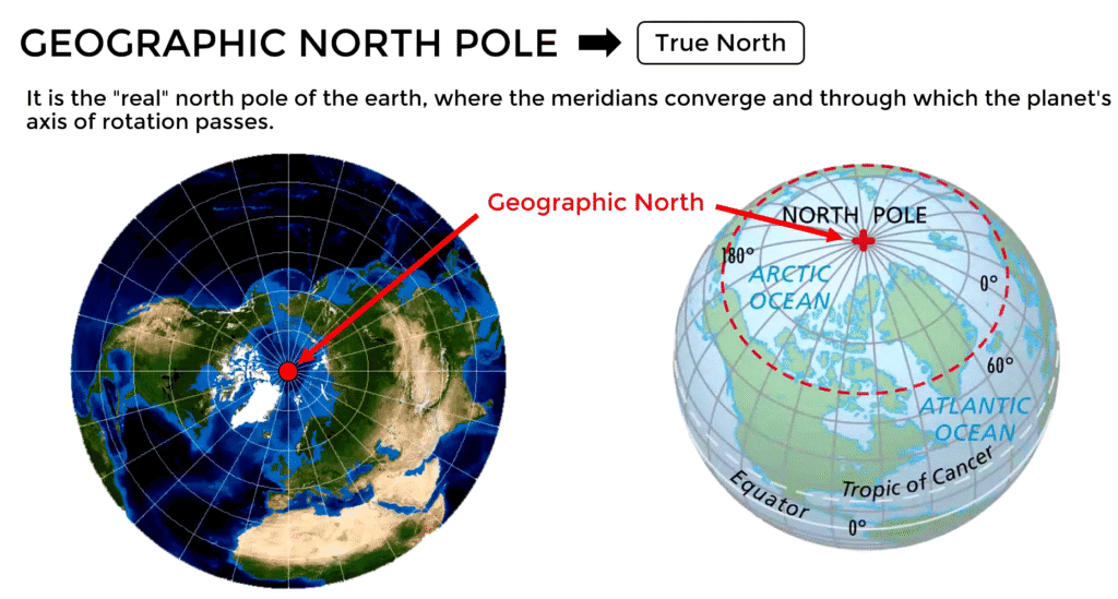
Declination is the angular difference between magnetic north and true north. Your compass points toward magnetic north, which is pulled by shifting iron deposits in the Earth’s core—not the actual North Pole. Depending on where you are in the world, this difference can range from almost nothing to over 20 degrees.
Proper declination navigation requires understanding this difference and compensating for it in all your bearing calculations. Without these skills, even the most expensive compass becomes nearly worthless for precision land navigation.
The Reality of Navigation Errors
| Error Distance | 1° Off | 5° Off | 10° Off | 15° Off |
|---|---|---|---|---|
| 1 mile | 92 feet | 460 feet | 920 feet | 1,380 feet |
| 2 miles | 184 feet | 920 feet | 1,840 feet | 2,760 feet |
| 5 miles | 460 feet | 2,300 feet | 4,600 feet | 6,900 feet |
| 10 miles | 920 feet | 4,600 feet | 9,200 feet | 13,800 feet |
Poor declination navigation work doesn’t just put you off course—it can be deadly. A 1° error over one mile puts you ~92 feet off target. A 5° error stretches into ~460 feet. Multiply that over several miles, and you’ll completely miss your water source, trail, or bug-out rendezvous.
Global Declination Patterns
WORLD DECLINATION MAP (Simplified)
         20°W    10°W     0°     10°E    20°E
      ┌─────────────────────────────────────┐
 70°N │  🧭15°W   🧭8°W   🧭0°   🧭12°E  🧭│
      │                                     │
 50°N │  🧭20°W  🧭12°W   🧭3°W   🧭8°E   🧭│
      │                                     │
 30°N │  🧭15°W   🧭5°W   🧭2°E  🧭15°E   🧭│
      │                                     │
 10°N │  🧭10°W   🧭2°W   🧭5°E  🧭18°E   🧭│
      └─────────────────────────────────────┘
US Declination by Region
Understanding regional variations is crucial for effective navigation across the United States.
Current Declination Values (2024-2025)
| Region | Declination Range | Major Cities | Navigation Notes |
|---|---|---|---|
| Pacific Northwest | 13-16° East | Seattle, Portland | High easterly declination required |
| California | 10-15° East | San Francisco, LA | Varies significantly N-S |
| Southwest | 8-12° East | Phoenix, Las Vegas | Moderate easterly declination |
| Rocky Mountains | 6-12° East | Denver, Salt Lake City | Changes with elevation |
| Great Plains | 0-5° East/West | Kansas City, Dallas | Near agonic line – minimal correction |
| Great Lakes | 2-8° West | Chicago, Detroit | Transitional zone |
| Northeast | 10-16° West | Boston, New York | High westerly declination required |
| Southeast | 4-8° West | Atlanta, Miami | Moderate westerly declination |
| Alaska | 15-25° East | Anchorage, Fairbanks | Extreme easterly – advanced skills needed |
| Hawaii | 8-12° East | Honolulu | Consistent easterly declination |
Special Note: The agonic line (zero declination needed) runs roughly through the Great Lakes, eastern Illinois, western Kentucky, eastern Tennessee, western Georgia, and into the Gulf of Mexico.
Why You MUST Master Declination Navigation
Critical Reasons for Accuracy
| Scenario | Why Declination Matters | Potential Consequences |
|---|---|---|
| Water Location | Miss the only spring for miles | Dehydration, emergency situation |
| Trail Junction | Take wrong fork in path | Extended hiking, lost time/energy |
| Bug-out Route | Miss cached supplies | Lack of critical resources |
| Emergency Signaling | Wrong location for rescue | Delayed or failed rescue |
| Hunting/Fishing | Miss productive areas | Failed food procurement |
Professional Standards
- Military: All bearing calculations include declination navigation correction
- Search & Rescue: Teams rely on precise declination navigation for life-saving operations
- Mountaineering: Alpine rescue depends on accurate position reporting
- Land Surveying: Legal property boundaries require true north references
Complete Step-by-Step Instructions
Learning proper techniques is essential for any serious outdoorsman or prepper.
Step 1: Find Your Area’s Declination Values
Method 1: USGS Topographic Maps
- Check the bottom margin of your USGS topo map
- Look for the declination diagram with degree measurements
- Note the year of magnetic data (crucial for accuracy)
Method 2: Online Resources
- NOAA Magnetic Field Calculator
- USGS Declination Calculator
- GPS Apps: Many smartphone apps display current declination values
Method 3: Local Resources
- Contact local orienteering clubs for training
- Check with park rangers or forest service for regional data
- Consult hiking/climbing guide services for instruction
Step 2: Understanding Map Declination Diagrams
TYPICAL USGS MAP DECLINATION DIAGRAM:

    TN        MN
     |       ↗
     |     ↗  14.5° E
     |   ↗
     | ↗
     |↗_____________ GN

Legend:
TN = True North (grid lines on map)
MN = Magnetic North (compass needle)
GN = Grid North (map projection)
Step 3: Know Your Compass Type
Understanding your compass type is fundamental to effective navigation.
Adjustable Declination Compasses
| Model | Price Range | Key Features | Best For |
|---|---|---|---|
| Suunto MC-2G | $80-120 | Global needle, mirror, adjustable | Beginners learning declination navigation |
| Brunton TruArc 5 | $35-50 | Fixed declination, luminous dial | General use |
| Silva Ranger 2.0 | $60-80 | Precision sighting, robust build | Professional navigation |
| Suunto A-10 | $25-40 | Basic adjustment, lightweight | Budget option |
Non-Adjustable Compasses
| Model | Price Range | Key Features | Best For |
|---|---|---|---|
| Cammenga 3H Military | $110-120 | Tritium illumination, bombproof | Military/tactical use |
| Brunton Pocket Transit | $400-450 | Geological features, high precision | Professional surveying |
| Silva Starter | $15-30 | Basic navigation, durable | Learning/backup |
Step 4: Declination navigation Correction Methods
Mastering correction techniques is the heart of accurate land navigation.
The Mathematical Approach (because we all LOVE math)
Remember the Rule:
- East Declination: Subtract from compass bearing
- West Declination: Add to compass bearing
Memory Device: “East is Least, West is Best“
Practical Examples
Example 1: Eastern US (West Declination)
- Location: Virginia
- Declination: 8° West
- Map bearing to target: 045°
- Corrected bearing: 045° + 8° = 053°
Example 2: Western US (East Declination)
- Location: Oregon
- Declination: 14° East
- Map bearing to target: 180°
- Corrected bearing: 180° – 14° = 166°
Example 3: Great Lakes (Near Zero)
- Location: Illinois
- Declination: 1° West
- Map bearing to target: 270°
- Corrected bearing: 270° + 1° = 271°
Step 5: Advanced Correction Techniques
Using Adjustable Compasses
- Set Once Method
- Rotate declination adjustment to local value
- All future readings automatically corrected
- Best for extended trips in same area
- Field Verification
- Sight known landmark on map
- Compare compass bearing to map bearing
- Adjust if necessary
Manual Correction Systems
The Field Card Method: Create a laminated reference card with:
- Local declination value
- Quick conversion examples
- Emergency backup calculations
The Bezel Method (for non-adjustable compasses):
- Add/subtract declination from all bearings
- Keep conversion chart accessible
- Practice until automatic
Advanced Declination Concepts
Temporal Changes in Declination
Understanding how values change over time is crucial for long-term accuracy.
Annual Change Rates (US Averages)
| Region | Annual Change | 10-Year Drift | Map Update Priority |
|---|---|---|---|
| Pacific Coast | +6-8 arcminutes/year | +1-1.3° | High priority updates |
| Rocky Mountains | +4-6 arcminutes/year | +0.7-1° | Medium priority |
| Great Plains | +2-4 arcminutes/year | +0.3-0.7° | Medium priority |
| Eastern US | +0-3 arcminutes/year | +0-0.5° | Low priority updates |
| Alaska | +8-12 arcminutes/year | +1.3-2° | Very high priority |
Note: 60 arcminutes = 1 degree
Grid vs. Magnetic vs. True North
The Three Norths Explained
| North Type | Definition | Used By | Navigation Impact |
|---|---|---|---|
| True North | Geographic North Pole | Maps, GPS coordinates | Reference standard |
| Magnetic North | Compass needle direction | Compasses (uncorrected) | Daily navigation use |
| Grid North | Map projection north | Survey/military grids | Technical mapping |
Convergence Angles
For most hiking/survival purposes, ignore grid convergence unless:
- Using military grid coordinates (MGRS/UTM)
- Working with survey-grade precision
- Operating in extreme northern latitudes
Professional Navigation Techniques
Military Land Navigation Standards
US Army Protocols
- Always correct for declination on all bearing calculations
- Verify with back-bearings when possible
- Use terrain association to confirm compass work
- Maintain pace count for distance measurement
Common Military Mistakes to Avoid
| Error Type | Description | Prevention |
|---|---|---|
| Reverse correction | Adding when should subtract | Practice with local examples |
| Old data | Using outdated map information | Check publication dates |
| Mixing systems | Grid bearings with magnetic compass | Use consistent reference system |
| Ignoring local anomalies | Iron deposits affect compass | Test compass in different locations |
Search and Rescue Applications
SAR Team Standards
- Precision Requirements: ±2° accuracy minimum
- Documentation: All bearings recorded with declination noted
- Redundancy: Multiple team members verify critical bearings
- Communication: GPS coordinates AND compass bearings shared
Declination Around the World
International Hotspots
Extreme Declination Locations
| Location | Declination | Special Considerations |
|---|---|---|
| Northern Canada | 30°+ East | Rapid annual changes |
| Greenland | 40°+ West | Extreme magnetic anomalies |
| Magnetic North Pole | 90° (undefined) | Compass spins freely |
| Antarctic Coast | 60°+ variation | Southern magnetic complexities |
| Hudson Bay, Canada | 15-25° West | Large magnetic anomaly zone |
Travel Considerations
When traveling internationally:
- Research destination declination before departure
- Adjust compass settings upon arrival
- Verify with local sources
- Consider regional magnetic anomalies
Practical Field Exercises
Beginner Practice Routine
Week 1: Indoor Preparation
- Study local declination values
- Practice correction calculations
- Set up compass properly
- Learn memory devices
Week 2: Backyard Navigation
- Identify known landmarks for practice
- Take bearings to visible objects
- Practice with and without correction
- Compare results
Week 3: Local Park Navigation
- Use actual topographic map
- Navigate to specific map features using declination navigation
- Verify positions with GPS backup
- Time exercises
Week 4: Wilderness Application
- Plan actual hiking route
- Navigate using only map and compass
- Document any errors
- Refine techniques
Advanced Training Scenarios
Night Navigation Exercise
- Use red-filtered light only
- Navigate by compass bearing alone
- Practice in familiar area first
- Progress to unknown terrain
Weather Challenge Training
- Practice in rain/snow conditions
- Protect equipment properly
- Navigate in reduced visibility
- Use sound and other senses
Equipment Recommendations
Budget-Conscious Options ($20-50)
| Item | Brand/Model | Price | Key Features |
|---|---|---|---|
| Compass | Suunto A-10 | $25-35 | Adjustable declination |
| Map Case | Aqua Quest | $15-25 | Waterproof protection |
| Field Notebook | Rite in the Rain | $8-12 | Weatherproof notes |
Professional Setup ($100-200)
| Item | Brand/Model | Price | Key Features |
|---|---|---|---|
| Compass | Suunto MC-2G | $90-120 | Mirror, adjustable, global |
| Map Case | Ortlieb | $40-60 | Fully waterproof |
| GPS Backup | Garmin eTrex | $100-150 | Long battery life |
Expert Level ($200+)
| Item | Brand/Model | Price | Key Features |
|---|---|---|---|
| Compass | Brunton Geo Transit | $300-400 | Survey-grade precision |
| Mapping Software | Gaia GPS Pro | $40/year | Offline maps, declination overlay |
| Training Course | Local orienteering club | $50-200 | Hands-on instruction |
Technology Integration
GPS and Declination
Modern GPS Units
- Most automatically correct for declination
- Can display magnetic or true bearings
- Verify settings match your compass type
- Use as backup, not primary method
Smartphone Apps with Declination Support
| App Name | Platform | Key Features | Cost |
|---|---|---|---|
| Gaia GPS | iOS/Android | Offline maps, declination overlay | $20/year |
| AllTrails | iOS/Android | Trail maps, compass with correction | $30/year |
| Compass Steel 3D | iOS/Android | Real-time correction | Free |
| GPS Essentials | Android | Multiple tools | Free |
Digital Map Resources
Official Map Sources
- USGS Store: https://store.usgs.gov/ – Official topographic maps
- USFS Maps: https://www.fs.usda.gov/ – Forest Service maps
- National Geographic Maps: https://www.natgeomaps.com/ – Recreation maps
Online Mapping Platforms
- CalTopo: https://caltopo.com/ – Advanced online mapping
- Gaia GPS: https://www.gaiagps.com/ – Professional mapping service
- Avenza Maps: https://www.avenzamaps.com/ – Offline map platform
Common Mistakes and Solutions
Top 10 Declination Errors
| Error | Description | Solution |
|---|---|---|
| Ignoring entirely | Using magnetic bearings on true north maps | Always check and apply correction |
| Backwards correction | Adding when should subtract (or vice versa) | Use “East is Least” memory device |
| Outdated data | Using old map values | Check NOAA calculator for current values |
| Wrong compass assumption | Thinking compass auto-adjusts | Verify if compass has adjustment feature |
| Mixing bearing types | Using true bearings with magnetic compass | Stay consistent with reference system |
| Poor compass technique | Inaccurate compass readings | Practice proper holding/reading techniques |
| Metal interference | Taking bearings near metal objects | Move away from metal before readings |
| Rushed calculations | Math errors under pressure | Double-check calculations, use backup methods |
| Ignoring local anomalies | Not accounting for magnetic irregularities | Test compass in multiple locations |
| No verification | Never confirming accuracy | Use terrain features to verify position |
Troubleshooting Navigation Problems
When Your Navigation Goes Wrong
Step 1: Stop and Assess
- Don’t panic or rush decisions
- Examine current position carefully
- Review recent navigation choices
Step 2: Verify Equipment
- Check compass for damage/interference
- Confirm declination setting
- Test compass accuracy with known bearings
Step 3: Relocate Using Map
- Identify visible terrain features
- Take bearings to known landmarks
- Triangulate position using multiple bearings
Step 4: Plan Correction
- Plot corrected route to destination
- Choose conservative, verified path
- Mark current position for future reference
Seasonal and Environmental Considerations
Weather Impact on Navigation
Temperature Effects
| Temperature Range | Compass Impact | Mitigation Strategies |
|---|---|---|
| Above 32°F (0°C) | Normal operation | Standard procedures |
| 0°F to 32°F (-18°C to 0°C) | Slower needle response | Allow extra settling time |
| Below 0°F (-18°C) | Sluggish operation | Keep compass warm, use backup |
| Extreme cold | Potential freezing | Body heat warming, alcohol-filled compasses |
Precipitation Challenges
- Rain: Protect map and compass, use waterproof cases
- Snow: Clear compass face frequently, avoid metal accumulation
- Fog: Rely more on compass, shorter legs between checkpoints
- High winds: Shield compass from buffeting, stable reading position
Altitude Considerations
High-Altitude Navigation Factors
| Altitude Range | Special Considerations | Navigation Adjustments |
|---|---|---|
| Sea level – 5,000 ft | Standard conditions | Normal procedures |
| 5,000 – 10,000 ft | Thinner air, weather changes | Monitor weather, plan escape routes |
| 10,000 – 14,000 ft | Altitude sickness possible | Conservative navigation, frequent checks |
| Above 14,000 ft | Extreme conditions | Expert-level skills required |
Legal and Safety Considerations
When Declination Navigation Matters Most
Emergency Situations
- Medical emergencies: Precise location for rescue coordination
- Natural disasters: Evacuation route navigation
- Severe weather: Finding shelter or safe passage
- Equipment failure: Backup navigation methods
Legal Implications
- Search and rescue costs: Some areas charge for rescue services
- Wilderness permits: Accurate reporting required
- Property boundaries: Trespassing avoidance
- International borders: Precise navigation critical
Risk Management
Safety Protocols
- Tell someone your plan: Route, timeline, emergency contacts
- Carry backup methods: Multiple compasses, GPS, maps
- Know your limits: Don’t exceed skill/equipment capabilities
- Practice regularly: Maintain and improve skills
- Check weather: Conditions affect navigation difficulty
Wrapping Up: From Theory to Mastery
The first time I ignored declination navigation was during a hike in the Ozarks. My map said I should be following a ridge to a spring. Instead, I was standing in a cow pasture wondering how Bessie got her own contour line. Four degrees off doesn’t sound like much—until you’re lost, thirsty, and trying to explain to your buddies why your “shortcut” turned into a three-mile detour.
Declination navigation isn’t glamorous. It’s not fire-starting with a soda can or building a spear trap. But it’s the quiet skill that separates confident navigators from people who need a helicopter ride home. Master it, and your map goes from paperweight to precision instrument.
The Path Forward
- Learn your local declination – Start with your home area
- Get the right equipment – Invest in quality compass and maps
- Practice regularly – Skills fade without use
- Study continuously – Navigation is a lifelong learning process
- Share knowledge – Teach others and learn from mistakes
Essential Resources and References
Government Resources
- NOAA National Centers for Environmental Information: https://www.ncei.noaa.gov/
- USGS National Map: https://apps.usgs.gov/nationalmap/
- National Weather Service: https://www.weather.gov/
Educational Organizations
- US Orienteering Federation: https://www.orienteeringusa.org/
- Leave No Trace: https://lnt.org/
- National Association for Search and Rescue: https://www.nasar.org/
Training and Certification
- Wilderness Medicine Institute: Advanced navigation courses
- NOLS (National Outdoor Leadership School): Professional outdoor education
- Local mountaineering clubs: Hands-on training opportunities
Final Thoughts: Your Navigation Journey
Declination navigation is the land navigation skill most beginners skip—until it costs them hours, miles, and pride. Don’t be that person wandering around like a lost Roomba. Learn it, practice it, and you’ll always know where you’re headed, whether you’re on a weekend hike or navigating to your bug-out location.
Your map deserves better than being a paperweight. And so do you.
Master declination navigation, and you join the ranks of navigators who can find their way anywhere, anytime, with nothing more than a map, compass, and the knowledge to use them correctly. That’s a skill worth developing—and a confidence worth earning.
Affiliate Disclaimer: Some links in this post are sponsored or affiliate links. If you click and buy, I may earn a small commission—enough to restock my peanut butter and maybe add one more can of chili to the stash. I only recommend gear I trust, use, and would hide in a bug-out bag.