
Terrain Association for Preppers: how to Navigate Off-Grid Without GPS in 2025
If you haven’t noticed yet. I tend to geek out on Land Nav related content. I am very interested in this topic and how to become a better navigator in the field. Speaking of which, have you checked out Garand Thumbs comprehensive video on this Land Nav? If not I highly suggest watching it after you finish reading this post.
Master the essential survival skill that works when technology fails
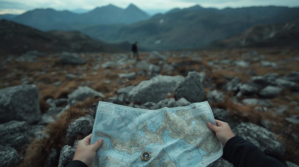
When disaster strikes and the grid goes down, your smartphone becomes a paperweight. Terrain association is the time-tested navigation method that could save your life when GPS fails, batteries die, or you need to move undetected through unfamiliar territory.
This comprehensive guide reveals everything you need to know about navigating using natural landmarks—from basic concepts to advanced techniques used by military professionals and seasoned preppers.
Why GPS Will Fail When You Need It Most
The harsh reality: 91% of U.S. adults depend on smartphones for navigation, making them helpless when technology fails.
The Growing Threat to GPS Systems
Recent data reveals alarming GPS vulnerabilities:
- Solar storms: NASA confirms that major solar flares can disrupt GPS signals for hours or days, especially as we approach the solar maximum period.
- Battery failure: 62% of hikers experience device battery failure on multi-day trips (Outdoor Industry Association, 2024).
- Signal loss: 68% of backcountry rescues in 2023 involved GPS signal failure in dense forests or canyons (National Park Service).
- Cyber threats: EMP attacks or cyberwarfare could disable satellite navigation systems entirely
Historical Examples of Navigation System Failures
During Hurricane Katrina in 2005, first responders and civilians successfully navigated flooded areas using paper maps and terrain features like levees and elevated roads when GPS and cellular networks failed completely.
Bottom line: Terrain association is as essential to preppers as water purification or fire-making skills.
What Is Terrain Association?
Terrain association is the art of navigation using natural and man-made landscape features to determine your location and plan routes. Instead of following a digital dot on a screen, you read the earth itself—matching hills, valleys, ridges, and rivers to a topographic map.
How It Works: The Basic Concept
Think of terrain association as reading the landscape like a book:
- Observe: Look around and identify distinctive features (ridges, streams, hills)
- Match: Find these same features on your topographic map
- Locate: Pinpoint your position where these features intersect
- Navigate: Plan your route using terrain for cover and efficiency
Key Terrain Features to Recognize
Elevation Features:
- Ridges: High ground forming the backbone of hills (contour lines form V-shapes pointing downhill)
- Valleys: Low ground between hills (V-shapes point uphill)
- Saddles: Low points between two peaks
- Spurs: Ridges extending from main hills
Water Features:
- Streams and rivers: Follow natural drainage patterns
- Lakes and ponds: Often found in low-lying areas
- Marshes and wetlands: Indicated by special symbols on maps
Man-Made Features:
- Roads and trails: Linear features for handrailing
- Power lines: Straight lines across terrain
- Buildings and structures: Reference points for location
Essential Tools for Off-Grid Navigation
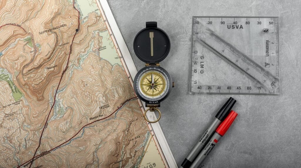
You don’t need expensive military gear to master terrain association. Here’s your minimal but effective toolkit:
Primary Tools
- Best choice: USGS 1:24,000 scale maps for detailed terrain information
- Waterproof versions: Essential for wet conditions
- Print backups: Never rely solely on digital copies
- Coverage: Get maps for your entire bug-out route
🧭 Compass (Optional but Recommended)
- Basic orienteering compass: Silva Ranger or similar quality
- Key features: Adjustable declination, sighting mirror
- Backup option: Button compass for emergency use
Secondary Tools
- Protractor: For measuring bearings and angles
- Waterproof markers: Mark routes and checkpoints
- Clear ruler: Measure distances on maps
- Magnifying glass: Read fine details on maps
🔦 Navigation Aids
- Red headlamp: Preserve night vision
- Waterproof case: Protect maps and compass
- Emergency whistle: Signal for help if needed
Step-by-Step Terrain Association Method
Master terrain association with this proven 5-step process:
Step 1: Orient Your Map
Goal: Align your map with the real world
- Use your compass: Place it on the map’s north arrow
- Rotate the map: Turn until the compass needle points to map north
- Account for declination: Adjust for the difference between magnetic and true north in your area
- Verify alignment: The map should now match your surroundings
Pro tip: Check NOAA’s declination calculator for your exact location’s magnetic variance.
Step 2: Identify Major Terrain Features
Look for prominent landmarks in this order:
- Large hills or mountains: Most visible and reliable features
- Water features: Rivers, streams, lakes (often follow predictable patterns)
- Linear features: Ridgelines, valleys, roads
- Unique formations: Isolated hills, distinctive bends in rivers
Key principle: Start with the most obvious features and work toward subtle details.
Step 3: Match Surroundings to Your Map
The critical skill: Finding your exact location
- Triangulate using 2-3 features: Never rely on just one landmark
- Look for unique combinations: A hill next to a stream bend, for example
- Consider elevation: Are you on high ground or in a valley?
- Verify with distances: Estimate how far features appear to be
Warning: Don’t guess. If you can’t confidently match features, keep searching or use additional methods.
Step 4: Plan Your Route Using Terrain
Smart route selection principles:
For concealment:
- Follow ridgelines: Natural cover from observation
- Use valleys: Hidden movement corridors
- Avoid skylines: Don’t silhouette yourself on hilltops
For efficiency:
- Contour around hills: Avoid unnecessary elevation changes
- Use handrails: Follow streams or ridges as guides
- Identify checkpoints: Plan stops to verify your position
Step 5: Navigate and Verify Position
Continuous verification process:
- Stop every 10-15 minutes: Check your position against the map
- Update your location: Mark progress on your map
- Reassess terrain: Have landscape features changed as expected?
- Adjust if needed: Correct course based on new observations
Critical habit: Never assume you’re still on course without verification.
Common Navigation Mistakes to Avoid
Learn from these frequent errors that can turn a simple navigation task into a survival situation:
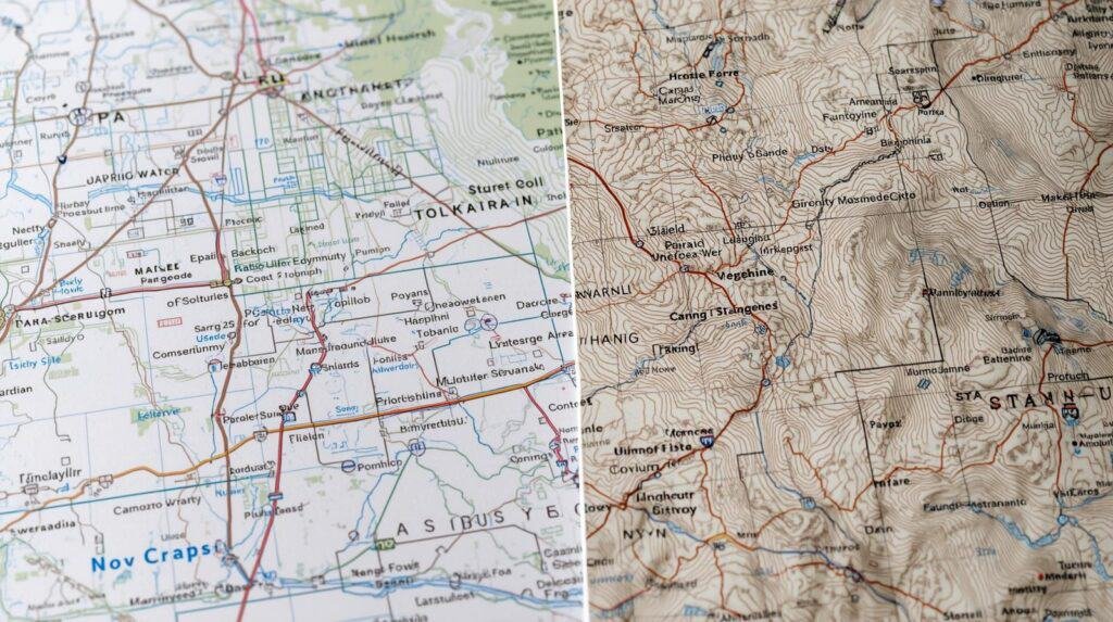
Mistake 1: Using the Wrong Map Type
The problem: Road maps or basic trail maps lack the detail needed for terrain association.
The solution: Always use topographic maps with contour lines showing elevation changes. USGS maps are the gold standard for accuracy and detail.
Mistake 2: Ignoring Magnetic Declination
The problem: Failing to account for the difference between magnetic north (where your compass points) and true north (map orientation).
The impact: Navigation errors of 10-20 degrees, leading you miles off course over long distances.
The solution: Always check and adjust for local declination before using your compass.
Mistake 3: Over-Relying on Single Features
The problem: Mistaking one hill for another similar-looking hill.
The solution: Always cross-reference at least 2-3 terrain features to confirm your position. Look for unique combinations rather than isolated landmarks.
Mistake 4: Practicing Only in Perfect Conditions
The problem: Learning navigation only in good weather and daylight conditions.
The reality: Emergencies don’t wait for perfect weather.
The solution: Practice in various conditions—rain, snow, darkness, and fog—to build real-world skills.
Mistake 5: Overconfidence Without Verification
The problem: Assuming you’re correct without double-checking position.
The consequences: Walking past your destination or into dangerous terrain.
The solution: Use “catch features” like major roads or rivers beyond your destination to prevent overshooting.
Advanced Techniques for Expert Navigation
Once you’ve mastered basic terrain association, these advanced methods will make you a navigation expert:
Triangulation Method
Purpose: Pinpoint your exact location using compass bearings
How it works:
- Identify two visible landmarks shown on your map
- Take compass bearings to each landmark
- Draw bearing lines on your map from each landmark
- Your position is where the lines intersect
When to use: When you need precise location data or can’t identify nearby terrain features.
Night Navigation Techniques
Challenges: Limited visibility, difficulty reading maps and compass
Solutions:
- Use red light: Preserves night vision while allowing map reading
- Practice route memorization: Study your path during daylight
- Rely on linear features: Roads, streams, and ridgelines are easier to follow in darkness
- Move slowly and deliberately: Take time to verify position frequently
Pace Counting for Distance
Purpose: Measure distance traveled without GPS
Method:
- Calculate your pace: Count steps for 100 meters on flat ground
- Adjust for terrain: Uphill = longer paces, downhill = shorter paces
- Track distance: Use pace beads or tally marks
- Verify regularly: Check against map features
Accuracy: Experienced navigators achieve 90%+ accuracy over distances up to 1 kilometer.
Terrain Association in Poor Visibility
Fog, rain, or snow conditions require modified techniques:
Sound navigation:
- Listen for water: Streams and rivers create distinctive sounds
- Traffic noise: Roads and highways produce consistent background noise
- Wildlife patterns: Birds and animals often indicate water or shelter
Handrailing method:
- Follow linear features: Stay close to streams, ridges, or roads
- Use back-bearings: Take compass readings to your starting point
- Create waypoints: Mark your path for potential retreat
Practice Drills to Master the Skill
Research shows: 85% of experienced navigators credit regular practice as the key to mastering terrain association skills.
Beginner Drills
Drill 1: Backyard Terrain Reading
- Time required: 30 minutes
- Materials: Topographic map of your area
- Method: Study your property and immediate neighborhood, identifying all terrain features on the map
Drill 2: Local Park Navigation
- Time required: 2 hours
- Location: Familiar hiking area with varied terrain
- Method: Pick a destination, navigate using only map and terrain features
Drill 3: Feature Identification Walk
- Time required: 1 hour
- Focus: Identify and name 10 different terrain features
- Goal: Build vocabulary and recognition skills
Intermediate Drills
Drill 4: Blind Navigation Challenge
- Method: Have a friend drive you to an unknown location
- Challenge: Navigate home using only map and compass
- Distance: Start with 1-2 mile routes
Drill 5: Route Planning Exercise
- Task: Plan three different routes to the same destination
- Focus: Consider stealth, speed, and resource availability
- Compare: Pros and cons of each route
Advanced Drills
Drill 6: Night Navigation Course
- Conditions: Navigate familiar route in complete darkness
- Tools: Red headlamp and compass only
- Goal: Build confidence for emergency situations
Drill 7: Weather Challenge Navigation
- Conditions: Practice in rain, snow, or fog
- Focus: Adapt techniques for limited visibility
- Safety: Always inform others of your plans
Joining Orienteering Communities
Benefits of organized practice:
- Structured learning: Progressive skill development
- Expert instruction: Learn from experienced navigators
- Competition element: Motivates consistent improvement
- Safety: Practice with others for emergency backup
Finding groups:
- Check Orienteering USA for local club listings
- Hiking clubs: Many offer navigation training
- Military surplus stores: Often know local navigation groups
- Outdoor retailers: REI and similar stores host navigation workshops
Real-World Applications for Preppers
Terrain association becomes critical in these common prepper scenarios:
Bug-Out Navigation

Scenario: You must evacuate quickly and avoid main roads
Application:
- Pre-planned routes: Study topographic maps of multiple evacuation paths
- Cache locations: Navigate to hidden supply points using terrain features
- Avoid detection: Use valleys and ridgelines to stay hidden
- Water sources: Find streams and springs marked on maps
Case study: During the 2017 California wildfires, many evacuees successfully used back-country routes when highways became impassable.
Grid-Down Communication
Scenario: You need to reach family members when phones and GPS are down
Application:
- Rendezvous points: Establish meeting locations based on terrain features
- Signal locations: Use hilltops for visual or radio communication
- Safe routes: Plan paths that avoid population centers
- Supply runs: Navigate to stores or resources in unfamiliar areas
Search and Rescue Operations
Scenario: Finding lost family members or helping neighbors
Application:
- Last known position: Use terrain association to track likely paths
- Water sources: People gravitate toward streams and rivers
- Shelter locations: Natural windbreaks and elevated dry ground
- Escape routes: Predict where someone might go for help
Long-Term Off-Grid Living
Scenario: Permanent or extended wilderness living
Application:
- Resource mapping: Locate water, game trails, and useful plants
- Seasonal changes: Understand how terrain affects weather patterns
- Security perimeters: Use natural features for defense planning
- Trade routes: Navigate to other communities or supply sources
Building Your Terrain Association Skills: Action Plan
Ready to master this essential prepper skill? Follow this progressive development plan:
Week 1-2: Foundation Building
- Study topographic maps of your local area for 30 minutes daily
- Practice feature identification during regular walks
- Learn compass basics and practice taking bearings
Week 3-4: Basic Application
- Navigate short routes using only map and compass
- Practice in familiar areas to build confidence
- Take notes on what works and what doesn’t
Month 2: Skill Development
- Extend navigation distances to 2-3 miles
- Practice in different weather conditions
- Join local orienteering events for structured learning
Month 3: Advanced Practice
- Night navigation exercises in safe, familiar areas
- Emergency scenario practice with time pressure
- Teach someone else to reinforce your own learning
Ongoing Development
- Monthly skill maintenance through regular practice
- Seasonal condition training as weather changes
- Advanced technique development like triangulation and pace counting
Essential Resources and References
Maps and Tools
- USGS Store: Official source for topographic maps (store.usgs.gov)
- CalTopo: Online mapping with printing options
- Compass recommendations: Silva, Suunto, or Brunton orienteering compasses
- Waterproofing: Map cases and laminating services
Training Resources
- Orienteering USA: Find local clubs and events
- Research shows: 85% of experienced navigators credit regular practice as the key to mastering terrain association skills.
- Military manuals: FM 3-25.26 Map Reading and Land Navigation
- Outdoor schools: NOLS and Outward Bound navigation courses
Scientific References
- NASA Solar Storm Impact Studies – Space weather effects on GPS systems
- Pew Research Center 2024 – Smartphone dependency statistics
- National Park Service – Backcountry navigation recommendations
- American Hiking Society – Navigation confidence surveys
- NOAA Magnetic Declination Calculator – Compass correction data
Conclusion: Your Navigation Independence Starts Now
When the grid fails and society breaks down, the ability to navigate without technology transforms from a nice skill to have into a life-or-death capability. Terrain association gives you the power to move confidently, find resources, avoid threats, and reach safety—regardless of what technology is working.
The statistics don’t lie: 91% of people depend entirely on smartphones for navigation. As a prepper, you’re choosing to be among the prepared 9% who can navigate when others are lost and helpless.
Your next steps:
- Download a topographic map of your area today
- Practice basic terrain association this weekend
- Build the skill progressively through regular training
- Share this knowledge with your prepper network
Remember: terrain association is a perishable skill. You can’t learn it by reading—you must get out and practice. Start simple, start local, and start now.
The question isn’t whether you’ll need this skill. The question is whether you’ll have it when that moment comes.
Heads-Up, Fellow Preppers:
Some links in this post are sponsored or affiliate links. If you click and buy, I may earn a small commission—enough to restock my peanut butter and maybe add one more can of chili to the stash. I only recommend gear I trust, use, and would hide in a bug-out bag.